Zhizhong LI
(China)

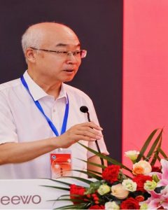
Professor Zhizhong Li is currently the director of the China SCO Geosciences Cooperation Research Center for Remote Sensing Applications, and the director of the green development research institute of western China. He is also an executive member of China Association of Remote Sensing Application, deputy director of its Remote Sensing Expert Committee. He earned Bachelor and Master degrees from China University of Geoscience in 1984 and 1987, respectively. Thereafter, he had worked in China Geological Survey since1987.
And then, he has been devoted to the development of aerospace remote sensing technology and RS applications. He has chaired more than 30 projects of Chinese National High Technology Research and Development Program (863 Program) and China Development and Reform Commission Projects, focused on the key technologies research in hyperspectral satellite payload, hyperspectral remote sensing in geology, remote sensing application in energy and mineral resources, and in environmental or geological hazards monitoring. As the chief scientist of Chinese National Programs for the research on key technologies for wide-area hyperspectral small satellite payloads, several breakthroughs have been made, such as satellite-based hyperspectral imaging full-link simulation model, thermal infrared hyperspectral data simulation method and hyperspectral data application in mineral mapping. Significant progresses have also been made in the constructions of geological application system based on hyperspectral satellite and geological management system based on the dual-satellite of the remote sensing satellites and navigation satellites. The research results are the directly driving force for the establishment and launch of China’s Gaofen-5 hyperspectral satellite (GF-5) project.
Professor LI’s main research fields are RS applications. He plays a vital and active role in promoting the global application of remote sensing technology, by chairing his working group cooperating with more than ten countries to jointly carry out multi-scale remote sensing survey, including surveying and monitoring of the global black soil critical zone, construction of the global spectrum database, and development of the remote sensing prototype system for global mineral and energy resources detection and evaluation. He advocated and proposed How to use remote sensing to effectively diagnose, identify and evaluate earth health? Which has received wide attention from many fields experts and was named one of the ten major science and technology issues in China 2022.
His main research expertise and achievements can be summarized as below:
- Established several key technologies in hyperspectral small satellite payload, which directly promote the establishment of China’s Gaofen-5 hyperspectral satellite project and the satellite launch.
- Developed a dual-satellite-based geological management system, built the first Chinese hyperspectral satellite demonstration system in geology and successfully promoted its application.
- Developed key technologies for global mineral and energy resources exploration and evaluation, and played an important role in promoting the international cooperations on hyperspectral remote sensing application.
- He proposed and organized the UNESCO international geoscience correlation project (IGCP665), established the international black soil society and the key laboratory for black soil evolution and the ecological effects of China Geological Survey.
Since 1987, Professor LI has published more than 70 papers, and has received some awards, prizes as follows:
- 2019, Second prize of science and technology progress: “Geological map of the People’s Republic of China (Northeast) (1:1500000) and its instructions”, Natural resources department of Liaoning Province.
- 2017, Second prize of science and technology progress: “Demonstration and application of global remote sensing exploration technology”, ranking No. 3, Ministry of Land and Resources of China.
- 2016, First prize of science and technology progress: “Remote sensing reconnaissance in Integrated Ground-air-space technology system and application demonstration”, ranking No. 2, Ministry of Land and Resources of China.
- 2014, First prize of national geographical information science and technology progress: the Key technology research and development of Modern field geological work management and service, Ranking No. 11.
- 2008, Second prize of science and technology progress of Hubei Province: Remote sensing monitoring technology for ecological environment of long-distance trans Basin Water Transfer Project, Ranking No.4.
- 2003, Second prize of science and technology achievements: Middle and high altitude aeromagnetic and microwave remote sensing technology, Ranking No.6.
- 2002, First prize for outstanding papers, Research on analysis of regional river bank change of Nanjing Yangtze River Third Bridge with multi temporal remote sensing data, China Geological Disaster Research Society and so on three societies.
- 2001, First prize excellent science papers, aerial remote sensing: Magical eye sees the earth, Ministry of Land and Resources of China.
Deputy Director, Professor,
Satellite Remote Sensing Application Center
Shanghai Cooperation Organization(SCO) Geoscience Research Center
No. 66, Tianshuijing, Lianhu District, Xi’an City, Shaanxi Province, China
Email: lizz2009@vip.163.com
